|
|
|
|
|
|
Navigation LakesnWoods.com
© 2004-2025 DCMA, Defamation, Copyright and Trademark Infingement Policy
|
|
|||||||||||||||||||||||||||||||||||||||||||||||||||||||||||||||||||||||||||||||||||||||||||||||||||||||||||||||||||||||||||||||||||||||||||||||||||||||||||||||||||||||||||||||||||||||||||||||||||||||||||||
 |
| Grant (city) | 1970 | 1980 | 1990 | 2000 | 2007 (est) |
1990-2000 Change | |
|---|---|---|---|---|---|---|---|
| Actual | Percent | ||||||
| Population | 1,853 | 3,083 | 3,778 | 4,026 | 4,096 | +70 | +1.74 |
| Land Area (sq. mile) | 23.60 | 28.27 | 25.81 | 25.68 | 25.68 | 0 | 0.00 |
| Density (persons per sq. mile) | 78.52 | 109.06 | 146.38 | 156.77 | 159.50 | +2.73 | +1.74 |
| Housing Units | 468 | 851 | 1,195 | 1,399 | 1,509 | +110 | +7.86 |
| Households | -- | 831 | 1,173 | 1,374 | 1,464 | +90 | +6.55 |
| Persons Per Household | -- | 3.68 | 3.20 | 2.93 | 2.80 | +0.13 | +4.44 |
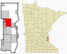
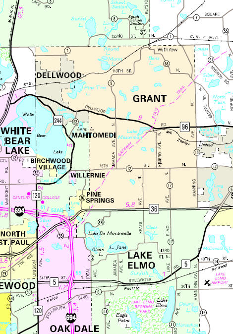
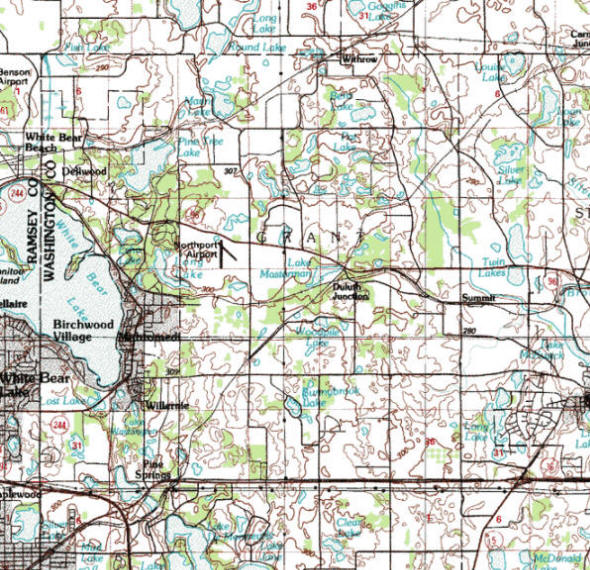
Grant is a city in Washington County, Minnesota. Minnesota State Highways 36 and 96 are two of the main routes in the community. According to the United States Census Bureau, the city has a total area of 27.0 square miles (70.0 km²), of which, 25.7 square miles (66.5 km²) of it is land and 1.3 square miles (3.4 km²) of it (4.92%) is water. The elevation is 1,010 ft (308 m) above sea level.
From Wikipedia, the free encyclopedia.
There were 1,374 households out of which 39.9% had children under the age of 18 living with them, 82.6% were married couples living together, 3.6% had a female householder with no husband present, and 11.5% were non-families. 9.1% of all households were made up of individuals and 3.0% had someone living alone who was 65 years of age or older. The average household size was 2.93 and the average family size was 3.11.
In the city the population was spread out with 28.1% under the age of 18, 5.3% from 18 to 24, 24.3% from 25 to 44, 34.2% from 45 to 64, and 8.1% who were 65 years of age or older. The median age was 42 years. For every 100 females there were 104.9 males. For every 100 females age 18 and over, there were 100.6 males.
The median income for a household in the city was $98,228, and the median income for a family was $104,601. Males had a median income of $65,441 versus $38,895 for females. The per capita income for the city was $44,486. About 1.7% of families and 1.8% of the population were below the poverty line, including 1.3% of those under age 18 and 9.5% of those age 65 or over.
Visit The
Minnesota History Shop! |
Courtesy Minnesota Historical Society
|
Grant City Hall 111 Wildwood Road PO Box 577 Willernie, MN 55090 Phone: (651) 426-3383 Regular Business Hours: Monday - Thursday 9:00 am - 12:00 pm City Council Meetings: 1st Tuesday of the month 


 |
 |
|||
| Title | Expires | Name & Address | Phone | |
| Mayor | 12/31/2022 |
Jeff Huber 9520 Joliet Avenue N Grant, MN 55082 |
|
(651) 470-9039 |
| Administrator/Clerk | appointed | Kim Points 111 Wildwood Road Willernie, MN 55090 |
|
(651) 426-3383 |
| Council Member | 12/31/2022 |
John Rog 9765 110th Street N Grant, MN 55082 |
|
(612) 867-1218 |
| Council Member | 12/31/2022 |
Jeff Giefer 11922 Imperial Avenue N Grant, MN 55038 |
|
(651) 207-8485 |
| Council Member | 12/31/2024 |
Jeff Schafer 8688 Jamaca Avenue N Grant, MN 55082 |
|
(651) 653-0743 |
| Council Member | 12/31/2024 |
Tom Carr 9550 Joliet Avenue Grant, MN 55082 |
|
(651) 303-8001 |
|
US Post Office 102 3rd Street N Stillwater, MN 55082-4830 Phone: (651) 439-7710 Toll Free: (800) ASK-USPS Fax: (651) 439-5882 |
|
||
|
|||
| Utility Type | Utility Name | Utility Phone |
| Electricity |
n/a |
-- |
| Natural Gas | n/a | -- |
| Wastewater | n/a | -- |
| Water | n/a | -- |
| Telephone | n/a | -- |
| Cable TV | n/a | -- |
| Employer | Products/Services | Employees |
|
n/a |
||
Minnesota State
Highway Map of the Grant Minnesota area
Check Out
The Minnesota
History Shop! Good Goods and
Great Gifts! |
| Lake Name | Size (acres) |
Lake info | Lake Map | Rec Map | Topo Map |
|---|---|---|---|---|---|
|
|
|
|
|
| Local | |
| Metro | |
|
see the Twin Cities Media Guide page for Twin Cities metro area newspapers, radio and TV |
|
|
|
|
|
© 2004-2025 LakesnWoods LLC All Rights Reserved |
|
|
|
||