|
|
|
|
|
|
Navigation LakesnWoods.com
© 2004-2025 DCMA, Defamation, Copyright and Trademark Infingement Policy
|
|
|||||||||||||||||||||||||||||||||||||||||||||||||||||||||||||||||||||||||||||||||||||||||||||||||||||||||||||||||||||||||||||||||||||||||||||||||||||||||||||||||||||||||||||||||||||||||||||||||||||||||||||||||||||||||||||||||||||||||||||||||||||||||
 |
 |
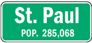
Saint Paul, abbreviated St. Paul, is the capital and second-most populous city in the U.S. state of Minnesota. The city lies mostly on the north bank of the Mississippi River, downstream of the river's confluence with the Minnesota River, and adjoins Minneapolis, the state's largest city. Known as the "Twin Cities", these two cities form the core of Minneapolis-Saint Paul, the sixteenth largest metropolitan area in the United States, with about 3.5 million residents. The city's population at the 2000 census was 287,151. Saint Paul serves as the county seat of Ramsey County, the smallest and most densely populated county in Minnesota.
| St. Paul (city) | 1970 | 1980 | 1990 | 2000 | 2010 | 2000-2010 Change | |
|---|---|---|---|---|---|---|---|
| Actual | Percent | ||||||
| Population | 309,866 | 270,230 | 272,235 | 287,151 | 285,068 | -2,083 | -0.73 |
| Land Area (sq. mile) | 52.30 | 54.33 | 52.79 | 52.77 | 52.77 | 0 | 0.00 |
| Density (persons per sq. mile) | 5,924.8 | 4,973.9 | 5,156.9 | 5,441.7 | 5,402.1 | -39.62 | -0.73 |
| Housing Units | 107,715 | 110,902 | 117,583 | 115,713 | 120,795 | +5,082 | +4.39 |
| Households | -- | 106,223 | 110,249 | 112,109 | 111,001 | -1,108 | -0.99 |
| Persons Per Household | -- | 2.44 | 2.37 | 2.46 | 2.57 | +0.11 | +4.47 |
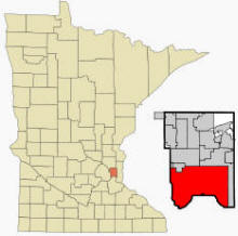
Saint Paul history and the city's growth as a landing port are tied to water. The city's defining physical characteristic, the Mississippi and connecting Minnesota Rivers were carved into the region during the last ice age. Fed by receding glaciers and Lake Agassiz ten thousand years ago, torrents of water from a glacial river undercut the river valleys. The city is situated in east-central Minnesota.
The Mississippi River forms a municipal boundary on part of the city's west, southwest and southeast sides. Minneapolis, the state's largest city lies to the west; Falcon Heights, Lauderdale, Roseville, and Maplewood are north; Maplewood is also to the east; the cities of West Saint Paul and South Saint Paul are to the south; and Lilydale, Mendota and Mendota Heights lie across the river from the city to the south. The city's largest lakes are Pig's Eye Lake, in the river, Lake Phalen, and Lake Como. According to the United States Census Bureau, the city has a total area of 56.2 square miles (145.5 km²). 52.8 square miles (136.7 km²) of it is land and 3.4 square miles (8.8 km²) of it (6.07%) is water.
From Wikipedia, the free encyclopedia.
There were 112,109 households, out of which 29.1% had children under the age of 18 living with them, 36.1% were married couples living together, 13.9% had a female householder with no husband present, and 45.6% were non-families. 35.9% of all households were made up of individuals and 9,4% had someone living alone who was 65 years of age or older. The average household size was 2.46 and the average family size was 3.32.
In the city the population was spread out with 27.1% under the age of 18, 12.5% from 18 to 24, 32.0% from 25 to 44, 18.0% from 45 to 64, and 10.3% who were 65 years of age or older. The median age was 31 years. For every 100 females there were 93.6 males. For every 100 females age 18 and over, there were 89.5 males.
The median income for a household in the city was $38,774, and the median income for a family was $48,925. Males had a median income of $35,111 versus $29,432 for females. The per capita income for the city was $20,216. About 11.7% of families and 15.6% of the population were living below the poverty line, including 23.2% of those under age 18 and 9.7% of those age 65 or over.
Visit The
Minnesota History Shop! |
"In 1841, in the month of October, logs were prepared and a church erected, so poor that it would well remind one of the stable at Bethlehem. It was destined, however, to be the nucleus of a great city. On the 1st day of November, in the same year, I blessed the new basilica, and dedicated it to 'Saint Paul, the apostle of nations.' I expressed a wish, at the same time, that the settlement would be known by the same name, and my desire was obtained. I had, previously to this time, fixed my residence at Saint Peter's [Mendota], and as the name of PAUL is generally connected with that of PETER, and the gentiles being well represented in the new place in the persons of the Indians, I called it Saint Paul. The name 'Saint Paul,' applied to a town or city, seemed appropriate. The monosyllable is short, sounds well, and is understood by all denominations of Christians. . . . Thenceforth the place was known as 'Saint Paul Landing,' and, later on, as 'Saint Paul'" (History of the City of Saint Paul by Williams, 1876, pp. 111-12).
The post office was established in St.
Croix County, Wisconsin Territory, on April 7, 1846; Jacob Wales Bass,
born in Vermont in 1815, came to
Prof. A. W. Williamson, in his list of
geographic names in this state received from the
As a familiar sobriquet,
A few districts of St. Paul have been
noted in the preceding list, namely
Farther northwest and southwest,
respectively, are the districts of
In and near
At
Courtesy Minnesota Historical Society
|
St. Paul City Hall 15 Kellogg Boulevard.W Saint Paul, MN 55102 Phone: (651) 266-8989 Fax: (651) 266-8574 Regular Business Hours: Monday - Friday 7:30 am - 4:30 pm City Council Meetings: Wednesdays at 3:30 pm 


 |
||||
| Title | Term Ends | Name and Address | Phone | |
| Mayor | 12/31/2023 |
Melvin Carter 428 Aurora Avenue Saint Paul, MN 5510 |
(651) 266-8510 | |
| Council Member - Ward 1 | 12/31/2023 |
Dai Thao 659 Blair Avenue Saint Paul, MN 5510 |
|
(651) 266-8610 (612) 715-8806 |
| Council Member - Ward 2 | 12/31/2023 |
Rebecca Noecker 14 Robie Street W Saint Paul, MN 5510 |
|
(651) 266-8620 (651) 314-9311 |
| Council Member - Ward 3 | 12/31/2023 |
Chris Tolbert 1257 Watson Avenue Saint Paul, MN 5510 |
|
(651) 266-8630 (651) 269-4786 |
| Council Member - Ward 4 | 12/31/2023 |
Mitra Jalali Nelson 765 N Hamden Avenue Saint Paul, MN 5510 |
|
(651) 266-8640 (612) 817-2373 |
| Council Member - Ward 5 | 12/31/2023 |
Amy Brendmoen 1045 Van Slyke Saint Paul, MN 5510 |
|
(651) 266-8650 (651) 492-8488 |
| Council Member - Ward 6 | 12/31/2023 |
Nelsie Yang 1283 Hazelwood Street Saint Paul, MN 5510 |
|
(651) 266-8660 (763) 291-3738 |
| Council Member - Ward 7 | 12/31/2023 |
Jane L. Prince 1004 Burns Avenue Saint Paul, MN 5510 |
|
(651) 266-8670 (651) 308-4984 |
|
US Post Office 180 Kellogg Blvd. E St. Paul, MN 55101-1438 Phone: (651) 293-6035 Toll Free: (800) ASK-USPS |
|
||
|
|||
| Utility Type | Utility Name | Utility Phone |
| Electricity | Xcel Energy | (800) 642-6066 |
| Natural Gas | Xcel Energy | (800) 642-6066 |
| Wastewater | Metropolitan Council Environmental Svc | (651) 222-8423 |
| Water | St. Paul Water Utility | (651) 266-6350 |
| Telephone | CenturyLink Communications | (800) 603-6000 |
| Cable TV | Comcast | (651) 222-3333 |
| Employer | Products/Services | Employees |
| State of Minnesota | Executive, Legislative, & Other Gen. Govt. Support | 13,671 |
| St Paul Public Schools | Elementary & Secondary Schools | 6,567 |
| Health East Care System/ St. Joesph's Hospital | General Medical & Surgical Hospitals | 5,080 |
| US Bank | Comm. Banking | 4,700 |
| Marsden Building Maintenance | Services to Buildings & Dwellings | 4,000 |
| Regions' Hospital | General Medical & Surgical Hospitals | 4,000 |
| Ramsey, County of | Executive, Legislative, & Other Gen. Govt. Support | 3,770 |
| St. Paul, City of | Executive, Legislative, & Other Gen. Govt. Support | 3,400 |
| United Hospital-Allini Health System | General Medical & Surgical Hospitals | 3,300 |
| US Post Office | Postal Service | 3,200 |
| 3M | Pulp, Paper & Paperboard Mills | 3,000 |
| St Paul Ramsey Med Ctr-Health Partners | General Medical & Surgical Hospitals | 3,000 |
| St Paul Companies Inc | Insurance Carriers | 2,650 |
| Minnesota Mutual Life Ins Co | Insurance Carriers | 2,400 |
| Ford Motor Co Assembly Plant | Motor Vehicle Manufacturing | 2,000 |
|
Downtown: |
|
View Larger Map |
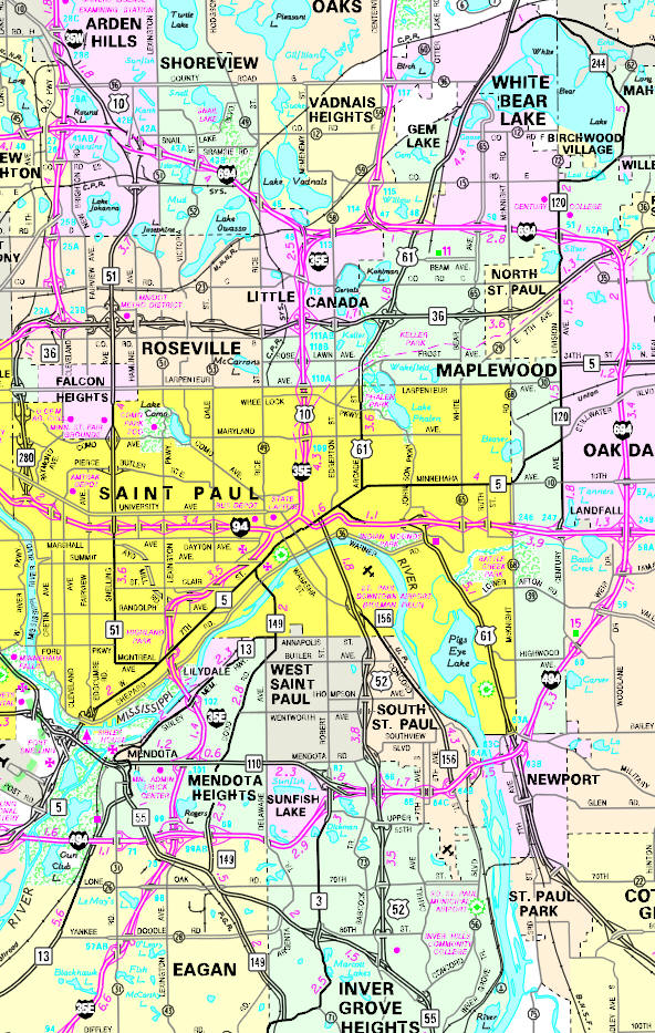
Minnesota State
Highway Map of the St. Paul, Minnesota area
Check Out
The Minnesota
History Shop! Good Goods and
Great Gifts! |
| Lake Name | Size (acres) |
Lake info | Lake Map | Rec Map | Topo Map |
|---|---|---|---|---|---|
|
|
|
|
|
| Local | |
| Metro | |
|
see the Twin Cities Media Guide page for Twin Cities metro area newspapers, radio and TV |
|
|
|
|
Downtown: |
|
View Larger Map |
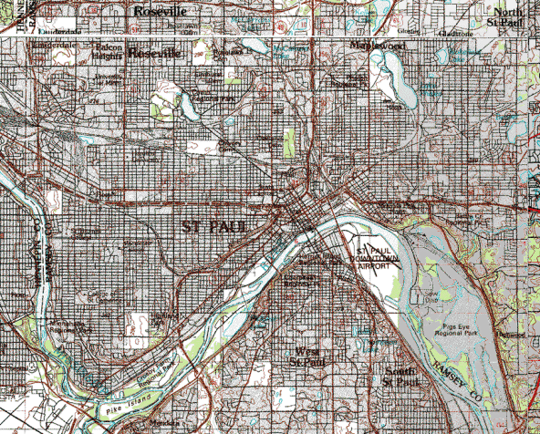
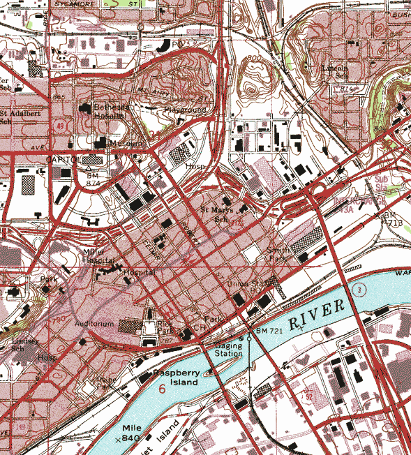
Topographic map is courtesy of the Minnesota DNR - click map to zoom or enlarge
|
|
|
|
© 2004-2025 LakesnWoods LLC All Rights Reserved |
|
|
|
||