|
|
|
|
|
|
Navigation LakesnWoods.com
© 2004-2025 DCMA, Defamation, Copyright and Trademark Infingement Policy
|
|
||||||||||||||||||||||||||||||||||||||||||||||||||||||||||||||||||||||||||||||||||||||||||||||||||||||||||||||||||||||||||||||||||||||||||||||||||||||||||||||||||||||||||||||||||||||||||||||||||||||||||||||||||||||||||||||||||||||||||||||||||||||||||||
|
|
|
| Rothsay (city) | 1970 | 1980 | 1990 | 2000 | 2010 | 2000-2010 Change | |
|---|---|---|---|---|---|---|---|
| Actual | Percent | ||||||
| Population | 301 | 278 | 253 | 271 | 493 | +222 | +81.92 |
| Land Area (sq. mile) | 0.50 | 1.95 | 2.03 | 2.03 | 4.00 | +1.97 | +97.04 |
| Housing Units | 121 | 126 | 120 | 117 | 250 | +133 | +113.68 |
| Households | -- | 116 | 107 | 103 | 211 | +108 | +104.85 |
| Persons Per Household | -- | 2.40 | 2.36 | 2.63 | 2.34 | -0.29 | -11.03 |
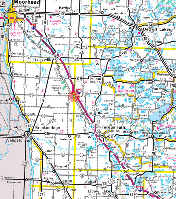
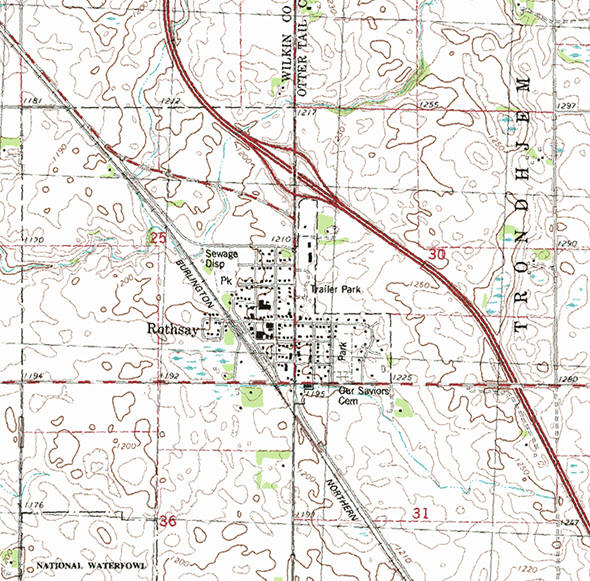
Rothsay is a city in Otter Tail and Wilkin counties in the State of Minnesota. Interstate Highway 94, Center Street, and Main Avenue are three of the main routes in the community.According to the United States Census Bureau, the city has a total area of 0.88 square miles (2.28 km2), all of it land. The elevation is 1,211 feet (369 m).
From Wikipedia, the free encyclopedia.
As of the census of 2010, there were 493 people, 211 households, and 140 families residing in the city. The population density was 560.2 inhabitants per square mile (216.3/km2). There were 250 housing units at an average density of 284.1 per square mile (109.7/km2). The racial makeup of the city was 98.8% White, 0.8% Native American, and 0.4% Asian. Hispanic or Latino of any race were 0.2% of the population.
There were 211 households of which 32.7% had children under the age of 18 living with them, 49.8% were married couples living together, 9.5% had a female householder with no husband present, 7.1% had a male householder with no wife present, and 33.6% were non-families. 28.4% of all households were made up of individuals and 11.4% had someone living alone who was 65 years of age or older. The average household size was 2.34 and the average family size was 2.80.
The median age in the city was 37.1 years. 25.8% of residents were under the age of 18; 5.7% were between the ages of 18 and 24; 28.8% were from 25 to 44; 24% were from 45 to 64; and 15.8% were 65 years of age or older. The gender makeup of the city was 51.3% male and 48.7% female.
Visit The
Minnesota History Shop! |
Courtesy Minnesota Historical Society
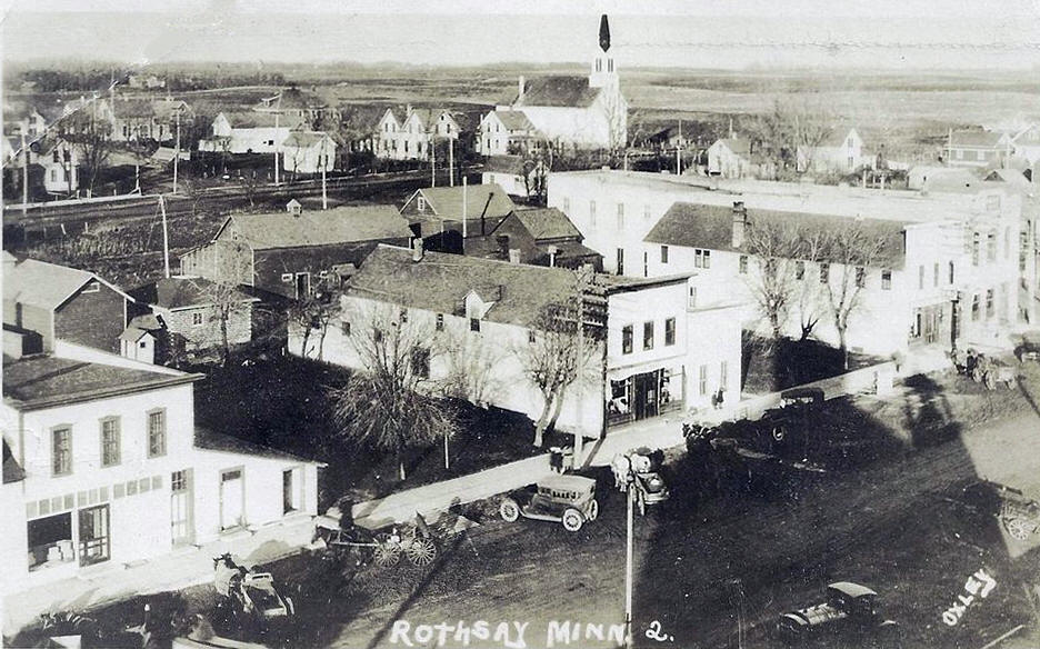 General view, Rothsay Minnesota, 1910 LakesnWoods.com Postcard and Postcard Image Collection - click to enlarge Visit The Rothsay Photo Gallery for more recent and historic area photos |
|
Rothsay City Hall 108 2nd Street NW PO Box 117 Rothsay, MN 56579 Phone: (218) 867-2254 Fax: (218) 867-2147 Regular Business Hours: Monday - Thursday 9:00 am - 3:00 pm City Council Meetings: 1st Monday of the month at 7:00 pm 


 |
||||
| Title | Term Ends | Name and Address | Phone | |
| Mayor | 12/31/2022 | Joe Tillman 506 W Main Avenue Rothsay, MN 56579 |
|
(701) 371-5992 |
| Clerk/Treasurer | appointed | Lisa Zimmerman PO Box 117 Rothsay, MN 56579 |
|
(218) 867-2254 |
| Council Member | 12/31/2022 | Darrell "Tolly"
Tollefson 111 2nd Street SE Rothsay, MN 56579 |
|
(218) 770-8966 |
| Council Member | 12/31/2022 | Daryl Schleeter 109 1st Avenue SW Rothsay, MN 56579 |
|
(218) 867-2333 |
| Council Member | 12/31/2024 | Anthony Harris 115 3rd Street SW Rothsay, MN 56579 |
|
(701) 866-9227 |
| Council Member | 12/31/2024 | Tulsa-Leigh Kugler
316 NW Terrace Drive Rothsay, MN 56579 |
|
(218) 770-4609 |
|
US Post Office 211 1st Street SW Rothsay, MN 56579-9998 Phone: (218) 867-2447 Toll Free: (800) ASK-USPS
Regular Business Hours:
|
|
| Utility Type | Utility Name | Utility Phone |
| Electricity | Otter Tail Power Company | (218) 739-8200 |
| Natural Gas | n/a | -- |
| Wastewater | City of Rothsay | (218) 867-2254 |
| Water | City of Rothsay | (218) 867-2254 |
| Telephone | Park Region Telephone | (218) 826-6161 |
| Cable TV | n/a | -- |
| Employer | Products/Services | Employees |
|
n/a |
||
| none |
Check Out
The Minnesota
History Shop! Good Goods and
Great Gifts! |
| none |
| none |
| Lake Name | Size (acres) |
Lake info | Lake Map | Rec Map | Topo Map |
|---|---|---|---|---|---|
| none in the immediate area | |||||
| none |
|
Rothsay School |
| Hamar Lutheran Church 102 Main Avenue W Rothsay, MN 56579 Phone: (218) 867-2166 |
|
| Hedemarken Lutheran Church 13208 300th Street Rothsay, MN 56579 Phone: (218) 736-7723 |
|
| Little Bethany Lutheran Rothsay, MN 56579 Phone: (218) 493-4300 |
|
| New Life Lutheran Parish 102 Main Avenue W Rothsay, MN 56579 Phone: (218) 867-6557 |
|
| Our Savior's Church 105 1st Street SW Rothsay, MN 56579 Phone: (218) 867-2421 |
|
| Rothsay Baptist Church 122 2nd Street NW Rothsay, MN 56579 Phone: (218) 867-2268 |
|
| South Immanuel Church 38041 County Highway 21 Rothsay, MN 56579 Phone: (218) 867-2327 |
| none |
| Comfort Zone Inn 412 Center St N Rothsay, MN 56579 Phone: (218) 867-2777 |
| none |
| none |
| Comfort Zone Inn 412 Center St N Rothsay, MN 56579 Phone: (218) 867-2777 |
|
| County Garage 1503 303rd Avenue Rothsay, MN 56579 Phone: (218) 867-2594 |
|
| Endless Energy-Agri-S-C 33316 County Highway 11 Rothsay, MN 56579 Phone: (218) 867-2336 |
|
| Evelo Inc 14314 County Highway 28 Rothsay, MN 56579 Phone: (218) 867-2724 |
|
| Fosse Transport 123 3rd Avenue SE Rothsay, MN 56579 Phone: (218) 867-2256 |
|
| Goltz Insurance 203 1st Avenue SW Rothsay, MN 56579 Phone: (218) 867-2772 |
|
| Grina Funeral Home 125 Center Street N Rothsay, MN 56579 Phone: (218) 867-2260 |
|
| Kacee's Home Care 507 Main Avenue W Rothsay, MN 56579 Phone: (218) 867-2722 |
|
| Kapow Photo 412 Center Street N Rothsay, MN 56579 Phone: (218) 867-2299 |
|
| Kathy's Day Care 307 4th Street SE Rothsay, MN 56579 Phone: (218) 867-2196 |
|
| Lindberg Motor Co 112 1st St SW Rothsay, MN 56579 Phone: (218) 867-2355 |
|
| Neuleib Repair Shop 118 Center Street N Rothsay, MN 56579 Phone: (218) 867-2105 |
|
| Ohe's Gravel & Dirt 13727 County Highway 28 Rothsay, MN 56579 Phone: (218) 867-2516 |
|
| Ole & Lena's Pizzeria 134 1st Avenue SW Rothsay, MN 56579 Phone: (218) 867-2500 |
|
| Original Heating Man 13165 300th Street Rothsay, MN 56579 Phone: (218) 736-4949 |
|
| Oscar/Parke Mutual Ins Co 301 N Circle Drive Rothsay, MN 56579 Phone: (218) 867-2440 |
|
| Partners 203 1st Avenue SW Rothsay, MN 56579 Phone: (218) 867-1234 |
|
| PNS Inventory Service 38401 County Highway 21 Rothsay, MN 56579 Phone: (218) 863-4313 |
|
| Productive Advertising 13165 300th Street Rothsay, MN 56579 Phone: (218) 736-4949 |
|
| Rothsay City Hall 108 2nd Street NW Rothsay, MN 56579 Phone: (218) 867-2254 |
|
| Rothsay Community Center 115 2nd St SW Rothsay, MN 56579 Phone: (218) 867-2343 |
|
| Rothsay Farmers Co-Op 305 1st Avenue SW Rothsay, MN 56579 Phone: (218) 867-2135 |
|
| Rothsay Fire Department 108 2nd St NW Rothsay, MN 56579 Phone: (218) 867-2310 |
|
| Rothsay Garage 108 Main Avenue W Rothsay, MN 56579 Phone: (218) 867-2740 |
|
| Rothsay Police Department Rothsay, MN 56579 Phone: (218) 867-2242 |
|
| Rothsay Powershouse Liquors 436 Center Street N Rothsay, MN 56579 Phone: (218) 867-2110 |
|
| Rothsay School 123 2nd Street NW Rothsay, MN 56579 Phone: (218) 867-2117 |
|
| Rothsay Seed Company 315 Main Avenue W Rothsay, MN 56579 Phone: (218) 867-2263 |
|
| Rothsay Store Front 106 2nd Street SW Rothsay, MN 56579 Phone: (218) 867-2328 |
|
| Rothsay Superintendent's Office 123 2nd Street NW Rothsay, MN 56579 Phone: (218) 867-2735 |
|
| Rothsay Telephone Company 137 1st Street NW Rothsay, MN 56579 Phone: (218) 867-2111 |
|
| Rothsay Truck Stop & Cafe Inc 544 Center Street N Rothsay, MN 56579 Phone: (218) 867-2381 |
|
| Rothsay Waste Water 108 Main Avenue W Rothsay, MN 56579 Phone: (218) 867-2740 |
|
| Shirley's Service 106 Center St S Rothsay, MN 56579 Phone: (218) 867-2163 |
|
| State Farm Insurance Rothsay, MN 56579 Phone: (218) 867-2750 |
|
| Studio 3 Hair Design 201 1st Street NW Rothsay, MN 56579 Phone: (218) 867-2102 |
|
| Super Cars 10346 County Highway 24 Rothsay, MN 56579 Phone: (218) 867-2419 |
|
| Trosvik Inc 39640 County Highway 11 Rothsay, MN 56579 Phone: (218) 867-2298 |
|
| US Post Office 211 1st Street SW Rothsay, MN 56579 Phone: (218) 867-2447 |
|
| Velo Turkey Farms 14314 County Highway 29 Rothsay, MN 56579 Phone: (218) 867-2614 |
|
| Wanda's Day Care 415 Main Avenue W Rothsay, MN 56579 Phone: (218) 867-2169 |
|
| Wells Fargo Bank 119 2nd Street SW Rothsay, MN 56579 Phone: (218) 867-2121 |
|
| Wilkin County Garage 78 Main Avenue Rothsay, MN 56579 Phone: (218) 867-2269 |
|
|
|
|
© 2004-2025 LakesnWoods LLC All Rights Reserved |
|
|
|
||