|
|
|
|
|
|
Navigation
LakesnWoods.com © 2004-2024 DCMA, Defamation, Copyright and Trademark Infingement Policy
Minnesota State Bird Women's Light T-Shirt
|
|
||||||||||||||||||||||||||||||||||||||||||||||||||||||||||||||||||||||||||||||||||||||||||||||||||||||||||||||||||||||||||||||||||||||||||||||||||||||||||||||||||||||||||||||||||||||||||||||||||||||||||||
 |
 |
| Lower Red Lake Unorganized Territory | 1970 | 1980 | 1990 | 2000 | 2010 | 2000-2010 Change | |
|---|---|---|---|---|---|---|---|
| Actual | Percent | ||||||
| Population | 2,675 | 2,855 | 3,621 | 5,057 | 5,790 | +733 | +14.49 |
| Land Area (sq. mile) | 137.30 | 140.13 | 141.17 | 141.16 | 141.16 | 0 | 0.00 |
| Density (persons per sq. mile) | 19.48 | 20.37 | 25.65 | 35.82 | 41.02 | +5.20 | +14.49 |
| Housing Units | 576 | 720 | 1,016 | 1,378 | 1,780 | +402 | +29.17 |
| Households | -- | 686 | 929 | 1,323 | 1,715 | +392 | +29.63 |
| Persons Per Household | -- | 4.15 | 3.85 | 3.79 | 3.33 | -0.46 | -12.14 |
Redby is a census-designated place (CDP) within the Lower Red Lake unorganized territory in Beltrami County, Minnesota. According to the United States Census Bureau, the CDP has a total area of 12.1 square miles (31.5 km²), of which, 11.7 square miles (30.2 km²) of it is land and 0.5 square miles (1.2 km²) of it (3.95%) is water. The elevation is 1,217 ft (371 m) above sea level.
From Wikipedia, the free encyclopedia.
Visit The
Minnesota History Shop! |
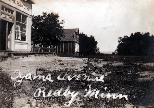
REDBY, an unincorporated village located on the south shore of Red Lake, on the Red Lake Reservation in T. 151N, R. 33W, section 20, received its name from the lake; its post office was established in 1907. It is the only community within the reservation that has taxable land under private ownership; industries include the Red Lake Indian Mills and the Red Lake Fisheries Association. The North West Fur Company had a trading post at the site.
Courtesy Minnesota Historical Society
Red Lake Develops Early Among County Communities
John G. Morrison, Jr. knew the Ojibwe people well. Residing on reservations for all but a few months of his life, he became an expert on both the government and the people influencing Indian life in northern Minnesota. John attended boarding school on the White Earth Reservation as a young man, and continued his education at the Carlisle Indian School in Pennsylvania in 1892. A few months later he returned to Minnesota, working in the Beaulieu, Ponsford, and Red Lake areas.
In 1896, he accepted a job with the U.S. Government's Indian Service, and for the next few years taught in federal reservation schools from Wisconsin to Washington. On October 1, 1900, he was transferred to Cross Lake on the northern shore of lower Red Lake, to start a school with his wife, Edith MacArthur Morrison. He also served as postmaster in the community of Ponemah.
In 1907, John left teaching to operate his father's general store in Red Lake and to become the Red Lake postmaster, Twelve years later he again changed careers, returning to White Earth to serve as a field man for the U.S. Government in managing Indian affairs. He continued working for his people in various federal capacities until 1940, when he retired with his wife to Redby.
|
|
John C. Morrison, Jr. Remembers...
As I remember Red Lake in 1888 it was a sprawling, long, narrow village along the lake, much as it is today. William R. Spears had a store there, which he had started in 1879 according to a sign on the front of it. He had started in his trading activities following the Indians around with a wagon when they were digging senaca root. He was a single man and spent his winters in a shack in Red Lake. When I first met him, he was right near Warren's stopping place where the Indians were digging the root. So many Indians were at work that he had root stored in a tent which he called "Snake Root City." Spear's original store was made of two logs long with staggered joints. It was about 400 feet from the Main street, just north on the road that runs down to the pow-wow grounds. Old Chief Moosedung had a little store downhill from Spears, on a side hill. The old American Fur Company store was right on the brown of the hill and Spears was in back of it.
It seems to me that Allan Jourdain had a little stock of goods in the American Fur Co. building. William Sayers, his brother-in-law, was clerking for him. He also owned the mail route and had the contract from White Earth to Red Lake, which he hired an Indian carrier to handle by packing on his back. One of the carriers was Nayzatkwigaowh, meaning man who stands alone. When he gave it up, Allan's brother, Peter Jourdain, carried the mail, generally with a little pony team. The Red Lake Post Office, the first in Beltrami County [established 1875], was at the Agency.
The Agency was in the same general location it is now and was headed by an overseer, Mr. Reed. I think there were five or six employees. There was no hospital there at that time but there was a doctor, possibly Dr. Laird. A small green schoolhouse was operated by the federal government. There was just one teacher who was called superintendent. The Agency blacksmith, carpenter, teamster, doctor and school employees probably brought the total number to ten people working for the government. There were, in addition, seven policemen. I believe they rotated a day apiece with a man always on duty.
There were no roads to speak of —just trails and mudholes.
The Indians in Red Lake raised a lot of vegetables at that time: corn, squash and potatoes. In the trader's store we used to buy corn. Seneca roots in the summertime and fur in the wintertime were used by the Indians for barter.
In 1888 the Catholics had a mission at the site of the cemetery which Father Aloysius visited from time to time, and late that fall Father Thomas Borgerding and some sisters arrived in Red Lake to maintain the mission on a full-time basis and start a school.
When I came back to Red Lake to work in 1893 things were picking up There were two main stores. I clerked for William Spears about two years. At that time Red Lake was the only town in Beltrami County area when you could buy a reasonable supply of groceries and other necessities of life. The county had not been organized and Red Lake was the only town in the county at that time. In 1893 it was largely a jumping-off place for homesteaders, steamboats and other settlers moving in. The lands settled on were largely those which had been ceded by the Indians of the Red Lake Reservation.
|
|
John B. Fairbanks had a little store in Red Lake and Tom Gurneau ran a little stopping place, a little log building with garret rooms for people who were forced to stay there overnight.
Steamboats had been running on Red Lake for probably two or three years when I came up here in 1893 to work. Captain Pete Eberhardt had a boat on Red Lake which he called The Viking. He made regular trips, depending upon the wind. If the wind was blowing from the west, the water was too low and he couldn't get into the lake. It was too shallow at the bar. This boat was probably 60-70 feet long. There was enough water in the Red Lake River to float it all the way down to Thief River Falls. Later on, another boat came on the lake. It was run by Herman Cook. Then the Alice Meehan came on, a passenger boat. Olaf Hanson ran a boat thatwouldn't go out on the lake but followed along the shore. He called it the Christina. And then there were quite a few towboats: the Martin Lally, the Michael Kelly, the Old Mudhen and the Jim Meehan. The Margarite, Chippewa, Beltrami and J.P. Kinney came on later. The lake was quite a highway. Quite a few boats towed logs across every day.
About 1893 and 1894 they were doing extensive logging up here. Bill Lennon came. C.A. Smith had a lot of holdings here and the walking boss was Fred Kribs — Fred and Al Kribs. The timber estimator was Jimmie Mullen. There was quite a bit of work being done on the lake. In the wintertime freighters from Terrebonne and Brooks and where Oklee is now hauled their beef and pork and eggs to us for the camps.
Red Lake was becoming busy with trading and supplying camps in the winter and driving and towing in the summer. Times were improving.
From "In Our Own Backyard" by Carol
Russell
© 1979, North Central Minnesota Historical Center
|
|
In 1918 the Red Lake General Council Constitution was established. In 1958 a revised Constitution and By-laws was adopted by the members of Red Lake Nation, followed by the first secret ballot election of Tribal Government in 1959.
An eleven member Tribal Council, three officers elected at large and eight council members, two from each of the four communities, governs the Red Lake Band. Seven Hereditary Chiefs, descendents from those who negotiated the 1889 Land Agreement, serve for life in an advisory capacity to the Tribal Council. In 1997, the Tribe began administering its own programs under a Self-Governance Contract with the BIA. Red Lake is not a member of the Minnesota Chippewa Tribe (MCT).
|
Red Lake Nation
Government Center 15484 Migizi Drive Red Lake, MN 56671 Phone: (218) 679-3341 Web: www.redlakenation.org |
 |
||
| Title | Term Ends | Name and Address | Phone |
|
Chairman |
n/a | Darrell G. Seki, Sr. | n/a |
| Secretary | n/a | Samuel R. Strong . | n/a |
| Treasurer | n/a | Annette Johnson | n/a |
| District Representative - Little Rock | n/a | Michelle Barrett-Cobenais . | n/a |
| District Representative - Little Rock | n/a | Adrian Beaulieu | n/a |
| District Representative - Ponemah | n/a | Glenda Martin | n/a |
| District Representative - Ponemah | n/a | Gary Nelson | n/a |
| District Representative - Red Lake | n/a | Robert "Bob" Smith | n/a |
| District Representative - Red Lake | n/a | Donald Good, Sr. | n/a |
| District Representative - Redby | n/a | Allen D. Pemberton | n/a |
| District Representative - Redby | n/a | Julius "Toady" Thunder | n/a |
|
US Post Office 101 3rd Street Redby, MN 56670-2000 Phone: (218) 679-2124 Toll Free: (800) ASK-USPS Regular Business Hours:
|
|
| Utility Type | Utility Name | Utility Phone |
| Electricity | Beltrami Electric Co-op | (218) 751-2540 |
| Natural Gas | n/a | -- |
| Wastewater | n/a | -- |
| Water | n/a | -- |
| Telephone | Paul Bunyan Telephone | (888) 586-3100 |
| Cable TV | n/a | -- |
| Employer | Products/Services | Employees |
|
n/a |
||
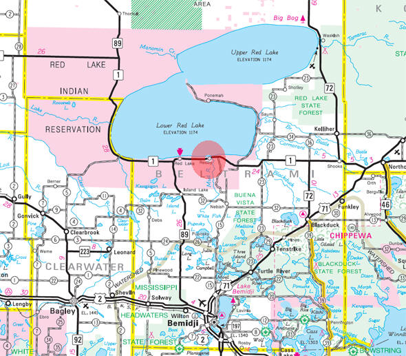
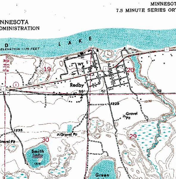
Minnesota State
Highway Map of the Redby Minnesota area
|
none |
Check Out
The Minnesota
History Shop! Good Goods and
Great Gifts! |
|
none |
|
none |
| Lake Name | Size (acres) |
Lake info | Lake Map | Rec Map | Topo Map |
|---|---|---|---|---|---|
| Lower Red | n/a | n/a | n/a |
|
|
|
none |
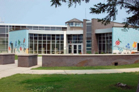
| Red Lake Nation College 23750 State Highway 1 E Red Lake, MN 56671 Phone: (218) 679-2860 |
|
|
Red Lake School District Independent School District #38 23990 State Highway 1 E PO Box 499 Red Lake, MN 56671 Phone: (218) 679-3353 Fax: (218) 679-2321 Web: www.Red Lake.k12.mn.us Grades: K-12 Students: n/a |
|
| Red Lake High School 23990 Highway 1 E Red Lake, MN 56671 Phone: (218) 679-3733 Grades: 7-12 Students: n/a |
 |
| Red Lake Middle School 23990 Highway 1 E Red Lake, MN 56671 Phone: (218) 679-2700 Grades: 6-8 Students: n/a |
|
| Red Lake Elementary School 24900 Elementary Street Red Lake, MN 56671 Phone: (218) 679-3329 Grades: 1-5 Students: n/a |
|
| Ponemah Elementary
School 25039 Abinoojiin Drive Ponemah, MN 56666 Phone: (218) 679-2375 Grades: K-8 Students: n/a |
|
none |
|
|
|
none |
|
none |
|
none |
|
none |
|
New Beginnings Child Care
Program State Highway 1 PO Box 416 Redby MN, 56670 Phone: (218) 679-3326 Web: www.mntrecc.net The New Beginnings Child Care Program is a department within the Whitefeather/Moe Training, Education & Technology Center under the Red Lake Reservation Tribal Government. The New Beginnings Child Care Program is funded through the Child Care Development Block Grant and is part of Public Law 102-477 along with five (5) other programs. |
|
|
Red Lake Nation Fishery 19050 State Highway 1 Redby MN, 56670 Phone: (218) 679-3513 Web: www.redlakewalleye.com Fresh Walleye, Perch and more are caught daily, year round, exclusively on Red Lake, the center of Tribal Life. All fish sold here are wild-caught by hand, by Red Lake Tribal Members. All proceeds come right back to the reservation and benefit its economic growth. |
|
| Red Lake Propane 19638 1st Street Redby MN, 56670 Phone: (218) 679-4418 |
|
| Redby Community Center State Highway 1 E Redby MN, 56670 Phone: (218) 679-5924 |
|
| Redby One Stop 19307 State Highway 1 E Redby MN, 56670 Phone: (218) 679-3655 |
|
| Redby Store 19320 State Highway 1 E Redby MN, 56670 Phone: (218) 679-3511 |
|
|
US Post Office 101 3rd Street Redby, MN 56670-2000 Phone: (218) 679-2124 Toll Free: (800) ASK-USPS Web: www.usps.com |
|
|
|
|
|||
|
|
© 2004-2024
Lakeweb1 Internet Services All Rights Reserved |
|
|
|
|||