|
|
|
|
|
|
Navigation LakesnWoods.com
© 2004-2025 DCMA, Defamation, Copyright and Trademark Infingement Policy
Walleye
Fear Me Hat
|
|
|||||||||||||||||||||||||||||||||||||||||||||||||||||||||||||||||||||||||||||||||||||||||||||||||||||||||||||||||||||||||||||||||||||||||||||||||||||||||||||||||||||||||||||||||||||||||||||||||||||||||||||||||||||||||||||||||||||||||||||||||||||||||
 |
| Plymouth (city) | 1970 | 1980 | 1990 | 2000 | 2007 (est) |
1990-2000 Change | |
|---|---|---|---|---|---|---|---|
| Actual | Percent | ||||||
| Population | 18,077 | 31,615 | 50,889 | 65,894 | 71,147 | 15,005 | 29.49 |
| Land Area (sq. mile) | 32.20 | 34.09 | 32.93 | 32.91 | -- | -0.02 | -0.05 |
| Density (persons per sq. mile) | 561.4 | 927.4 | 1,545.4 | 2,002.0 | -- | 456.59 | 29.55 |
| Housing Units | 4,825 | 11,039 | 19,616 | 25,258 | -- | 5,642 | 28.76 |
| Households | -- | 10,491 | 18,361 | 24,820 | 27,962 | 6,459 | 35.18 |
| Persons Per Household | -- | 2.96 | 2.72 | 2.60 | 2.48 | -0.12 | -4.50 |
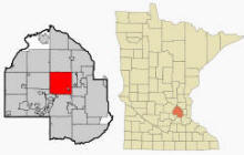
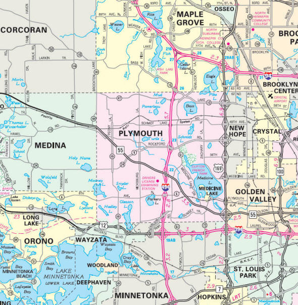
Plymouth is located 15 miles (24 km) northwest of downtown Minneapolis in Hennepin County, Minnesota. Interstate 494, U.S. Route 169, and Minnesota State Highway 55 are three of the main routes in the city. According to the United States Census Bureau, the city has a total area of 35.3 square miles (91.5 km²)—32.9 square miles (85.2 km²) of it is land and 2.4 square miles (6.2 km²) of it (6.82%) is water. The elevation is 971 ft (296 m) above sea level.
From Wikipedia, the free encyclopedia.
There were 24,820 households out of which 37.8% had children under the age of 18 living with them, 61.2% were married couples living together, 7.6% had a female householder with no husband present, and 28.9% were non-families. 21.8% of all households were made up of individuals and 4.7% had someone living alone who was 65 years of age or older. The average household size was 2.60 and the average family size was 3.09.
In the city the population was spread out with 27.1% under the age of 18, 7.4% from 18 to 24, 33.0% from 25 to 44, 25.0% from 45 to 64, and 7.6% who were 65 years of age or older. The median age was 36 years. For every 100 females there were 97.1 males. For every 100 females age 18 and over, there were 95.5 males.
The median income for a household in the city was $77,008, and the median income for a family was $90,134. Males had a median income of $59,751 versus $38,111 for females. The per capita income for the city was $36,309. About 1.5% of families and 2.6% of the population were below the poverty line, including 2.0% of those under age 18 and 1.5% of those age 65 or over.
Visit The
Minnesota History Shop! |
Plymouth's history can be traced back to the pre-Columbian period, 1400-1500 AD.[6] The original inhabitants were the Dakota. Their encampment was at the north end of Medicine Lake, whose name is derived from the Native American word "Mdewakan," meaning "Lake of the Spirit." The Dakota named it after a warrior overturned his canoe and his body was never recovered.
Antoine LeCounte, a guide and explorer, was the first settler to this area. He arrived in 1848, but did not settle until 1852. He carried mail from the Red River country to points south, trading goods to Native Americans for horses on the way. LeCounte built the first cabin at what is now East Medicine Lake Blvd. at 29th Ave. N. Plymouth's beginning as a town occurred in 1855 on the northwest shores of what is now known as Parkers Lake. A gristmill and other structures were built in the area. In the spring of 1857, when Parkers Lake flooded, the mill was taken down and moved to Freeport, Minnesota, known today as Wayzata.
As new settlers came to the area, they decided to organize. The Hennepin County Board of Commissioners named the new settlement Plymouth. On April 19, 1858, a group of townspeople met at the home of Francis Day to open elections for town offices. On May 11, 1858, the group voted to change the town's name to Medicine Lake. This was used once at the town meeting, but for reasons, which were not recorded, it was never used again.
During the Dakota War of 1862 between white settlers and the Dakota at Fort Ridgely, near New Ulm, the settlers of Plymouth formed a militia. When the Civil War started, Plymouth paid its volunteers $25 to enlist. At about this time, Plymouth's growth began to take on a new look. Schools and churches were built and a post office was located in Plymouth. By 1863, hotels were being built.
More changes occurred after the Civil War. By 1880, Plymouth boasted a population of 1,074, and reaped $667 in annual taxes. Farming became the trade of most settlers. Roads were built across Plymouth, making access to other towns possible. Medicine Lake had become a major tourist attraction and resorts were built around its shores.
As the character of the community evolved, so did local government. Plymouth incorporated as a village on May 18, 1955. The City adopted the Council-Manager form of government on August 1, 1968. Plymouth became a statutory city on February 7, 1974. It remained a statutory city until voters opted to make it a home rule charter city by adopting a City Charter on November 3, 1992. The City Charter went into effect on January 1, 1993. The Charter continued the Council-Manager form of government, and increased the size of the City Council. Prior to the adoption of the Charter, the City Council was made up of five members elected at-large. The Charter increased the Council to seven members elected from four wards.
In most recent news Plymouth was named by Money Magazine the number one city in which to live in the United States in 2008. The magazine gave top honors to Plymouth because of its inclusion of residential areas, industry, parks, schools, and other aspects which make Plymouth a self-contained and essentially autonomous city.
From Wikipedia, the free encyclopedia.
The city of
Courtesy Minnesota Historical Society
|
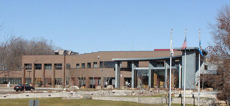
Plymouth City Hall 3400 Plymouth Boulevard Plymouth, MN 55447-1482 Phone: (763) 509-5000 Fax: (763) 509-5060 Regular Business Hours: Monday - Friday 8:00 am - 4:30 pm Open until 6:00 pm on Tuesdays City Council Meetings: 2nd and 4th Tuesday of the month at 7:00 pm 


 |
 |
|||
| Title | Term Ends | Name and Address | Phone | |
| Mayor | 12/31/2022 |
Jeffry Wosje 1760 Ranier Lane N Plymouth, MN 55447 |
|
(763) 509-5007 (952) 738-2399 |
| City Manager | appointed |
Dave Callister 3400 Plymouth Boulevard Plymouth, MN 55447 |
|
(763) 509-5300 |
| Council Member - Ward 1 (NW) | 12/31/2024 |
Alise McGregor 5110 Quantico Lane Plymouth, MN 55446 |
|
(763) 509-5001 (763) 269-2796 |
| Council Member - Ward 2 (SW) | 12/31/2022 |
Nick Roehl 415 Quantico Lane N Plymouth, MN 55447 |
|
(763) 509-5002 (612) 599-7331 |
| Council Member - Ward 3 (SE) | 12/31/2024 |
Jim Davis 880 Trenton Lane N Plymouth, MN 55447 |
|
(763) 509-5003 (612) 708-9704 |
| Council Member - Ward 4 (NE) | 12/31/2022 |
James Prom 5760 Oakview Lane Plymouth, MN 55447 |
|
(763) 509-5004 (612) 940-4238 |
| Council Member - At Large | 12/31/2022 |
Ned Carroll 19010 11th Avemue N Plymouth, MN 55447 |
|
(763) 509-5005 (612) 919-9717 |
| Council Member - At Large | 12/31/2024 |
Jim Willis 16511 26th Avenue N Plymouth, MN 55447 |
|
(763) 509-5006 (651) 485-0700 |
|
US Post Office 3300 Plymouth Blvd. Plymouth, MN 55447-9998 Phone: (763) 557-1372 Toll Free: (800) ASK-USPS |
|
||
|
|||
| Utility Type | Utility Name | Utility Phone |
| Electricity | Wright-Hennepin Cooperative Electric Assn | (763) 477-3000 |
| Electricity | Xcel Energy | (800) 895-4999 |
| Natural Gas | CenterPoint Energy | (800) 245-2377 |
| Wastewater | Metropolitan Council Environmental Services | (651) 602-1005 |
| Water | Plymouth Public Works | (763) 509-5950 |
| Telephone | CenturyLink Communications | (800) 244-1111 |
| Cable TV | Comcast | (651) 222-3333 |
| Employer | Products/Services | Employees |
| Carlson | Travel Agencies | 2,225 |
| Prudential Insurance Co | Direct Life Insurance Carriers | 1,600 |
| CenturyLink Communications | Wired TeleComm. Carriers | 700 |
| Boston Scientific | Electromedical & Electrotherapeutic Apparatus Mfg. | 600 |
| Honeywell Inc | Semiconductor & Related Device Mfg. | 500 |
| Select Comfort Corp | Furniture Stores | 475 |
| Upsher-Smith Laboratories Inc | Pharmaceutical Prep. Mfg. | 400 |
| US Food Service | Mobile Food Svcs. | 400 |
| Fortis Health | Direct Health & Medical Insurance Carriers | 390 |
| Deltak Corp | Power Boiler & Heat Exchanger Mfg. | 370 |
| Turck Inc | All Other Misc. Electrical Equip. & Component Mfg. | 322 |
| Wagner Spray Tech Inc | Paint & Coating Mfg. | 265 |
| Banner Engineering Corp | All Other Misc. Electrical Equip. & Component Mfg. | 260 |
| Nu-Aire Inc | Laboratory Apparatus & Furniture Mfg. | 250 |
| Buhler Inc | All Other Indus. Machinery Mfg. | 232 |
Minnesota State
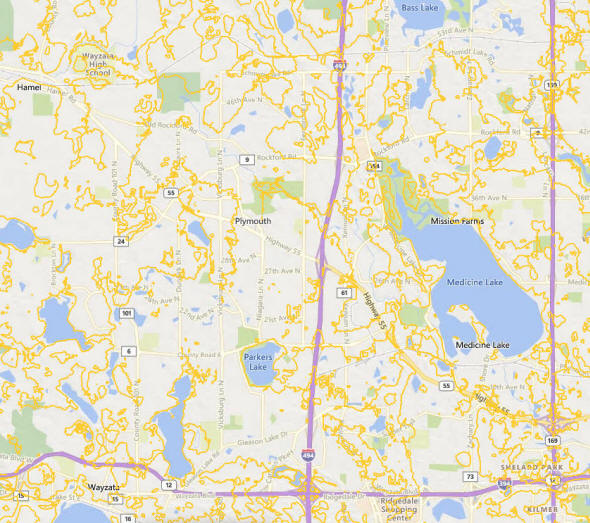
Highway Map of the Plymouth Minnesota area
Check Out
The Minnesota
History Shop! Good Goods and
Great Gifts! |
| Lake Name | Size (acres) |
Lake info | Lake Map | Rec Map | Topo Map |
|---|---|---|---|---|---|
|
|
|
|
|
| Local | |
| Metro | |
|
see the Twin Cities Media Guide page for Twin Cities metro area newspapers, radio and TV |
|
|
|
|
|
|
|
© 2004-2025 LakesnWoods LLC All Rights Reserved |
|
|
|
||