Navigation

LakesnWoods.com
  Home
Page
  Contact Us
  Privacy
  Minnesota History Shop

Visit The Minnesota History Shop
www.minnesotahistoryshop.com
Historic maps
Historic books
Historic framed art
Historic postcards

Clothing with historic images
And much more!!!


Minneapolis Guide:
  Photo Gallery
  Location
  Geography
  Demographics
  History
  Government
  Post Office
  News
  Weather
  Street Map
  Events
  Attractions
  Recreation
  Lakes
  Health Care
  Schools
  Churches
  Media
  Motels
  Resorts
  Campgrounds
  Businesses
  Aerial Photo
  Topographic Map

© 2004-2022
Lakeweb1 Internet Services
All Rights Reserved

DCMA, Defamation, Copyright and Trademark Infingement Policy

Bookmark and Share

WANTED!

Do you have photos, historical accounts or other items pertaining to the Minneapolis area? Would you like to share this historical information with the world? LakesnWoods.com would like to publish your Minneapolis photos (current or historical) or historical accounts on this website. Original materials can be returned and your privacy will be respected.

Contact us


Minneapolis, Minnesota Gallery - Maps


By Date:
1800s 1900s 1910s 1920s 1930s 1940s
1950s 1960s 1970s 1980s 1990s 2000s

By Topic:
Hotels/Motels Retail Parks Maps
Hospitals Industry Rail  
Theaters Schools Churches   

By Area:
Downtown Northeast North Southeast
South U of M Airport Fort Snelling


Plan of the City of Minneapolis and vicinity, from An illustrated historical atlas of the State of Minnesota, Published by A.T. Andreas, Lakeside Building, Chicago, Illinois, 1874.
Courtesy David Rumsey Map Collection - click image to enlarge (large file; may take a while to load)


Vintage Map of Minneapolis, MN from 1879
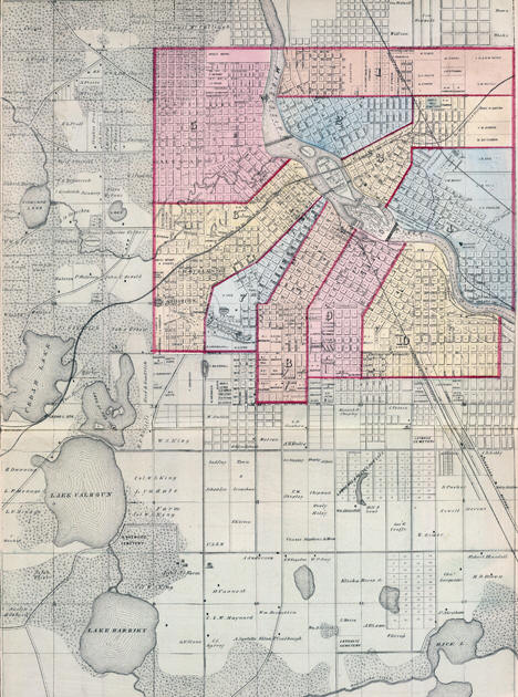
Vintage Map of Minneapolis, MN from 1879 - 24"x36" Wall Art

Vintage Map of Minneapolis, MN from 1885
Vintage Map of Minneapolis, MN from 1885 - 24"x36" Wall Art


Map of Minneapolis and St. Paul, from The New Encyclopedic Atlas and Gazetteer of the World, 1906
Courtesy University of Texas Library - click image to enlarge (large file; may take a while to load)


LakesnWoods.com    Home Page    Contact Us    Privacy   


© 2004-2022 Lakeweb1 Internet Services All Rights Reserved