|
|
|
|
|
|
Navigation LakesnWoods.com
© 2004-2025 DCMA, Defamation, Copyright and Trademark Infingement Policy
It's Time
to Fish! Clock |
|
|||||||||||||||||||||||||||||||||||||||||||||||||||||||||||||||||||||||||||||||||||||||||||||||||||||||||||||||||||||||||||||||||||||||||||||||||||||||||||||||||||||||||||||||||||||||||||||||||||||||||||||||||||||||||||||||||||||||||||||||||||||||||||||||||||||||
 |
| Minneapolis (city) | 1970 | 1980 | 1990 | 2000 | 2007 (est) |
1990-2000 Change | |
|---|---|---|---|---|---|---|---|
| Actual | Percent | ||||||
| Population | 434,400 | 370,951 | 368,383 | 382,618 | 388,020 | 14,235 | 3.86 |
| Land Area (sq. mile) | 53.40 | 56.88 | 54.93 | 54.89 | -- | -0.04 | -0.07 |
| Density (persons per sq. mile) | 8,134.8 | 6,521.6 | 6,706.4 | 6,970.3 | -- | 263.94 | 3.94 |
| Housing Units | 167,214 | 168,859 | 172,666 | 168,606 | -- | -4,060 | -2.35 |
| Households | -- | 161,858 | 160,682 | 162,352 | 167,367 | 1,670 | 1.04 |
| Persons Per Household | -- | 2.19 | 2.19 | 2.25 | 2.20 | 0.06 | 2.79 |
Minneapolis is the largest city in the U.S. state of Minnesota and is the county seat of Hennepin County. The city lies on both banks of the Mississippi River, just north of the river's confluence with the Minnesota River, and adjoins Saint Paul, the state's capital. Minneapolis has a total area of 58.4 square miles (151.3 km2) and of this 6% is water. The city's lowest elevation of 686 feet (209 m) is near where Minnehaha Creek meets the Mississippi River. The site of the Prospect Park Water Tower is often cited as the city's highest point and a placard in Deming Heights Park denotes the highest elevation, but a spot at 974 feet (296.88 m) in or near Waite Park in Northeast Minneapolis is corroborated by Google Earth as the highest ground.
From Wikipedia, the free encyclopedia.
At the 2005-2007 American Community Survey Estimates, the city's population was 68.1% White, 17.7% Black or African American, 1.3% American Indian and Alaska Native, 5.1% Asian, 0.0% Native Hawaiian and Other Pacific Islander, 4.7% from some other race and 3.0% from two or more races. 9.5% of the total population were Hispanic or Latino of any race.[44] 41.2% of the total population had a Bachelor's degree or higher.
Compared to a peer group of metropolitan areas in 2000, Minneapolis-Saint Paul is decentralizing, with individuals moving in and out frequently and a large young and Caucasian population and a low unemployment rate. Racial and ethnic minorities lag behind Caucasian counterparts in education, with 15.0% of African Americans and 13.0% of Hispanics holding bachelor's degrees compared to 42.0% of the Caucasian population. The standard of living is on the rise, with incomes among the highest in the Midwest, but median household income among African Americans is below that of Caucasians by over $17,000. Regionally, home ownership among African American and Hispanic residents is half that of Caucasians though Asian home ownership doubled. In 2000, the poverty rates included Caucasians at 4.2%, African Americans at 26.2%, Asians at 19.1%, American Indians at 23.2%, and Hispanics at 18.1%.
Visit The
Minnesota History Shop! |
Dakota Sioux were the region's sole residents until French explorers arrived around 1680. Nearby Fort Snelling, built in 1819 by the United States Army, spurred growth in the area. The United States Government pressed the Mdewakanton band of the Dakota to sell their land, allowing people arriving from the east to settle there. The Minnesota Territorial Legislature authorized present day Minneapolis as a town on the Mississippi's west bank in 1856. Minneapolis incorporated as a city in 1867, the year rail service began between Minneapolis and Chicago, and joined with the east bank city of St. Anthony in 1872.
Minneapolis grew up around Saint Anthony Falls, the highest waterfall on the Mississippi. Millers have used hydropower since the 1st century B.C., but the results in Minneapolis between 1880 and 1930 were so remarkable the city has been described as "the greatest direct-drive waterpower center the world has ever seen." In early years, forests in northern Minnesota were the source of a lumber industry that operated seventeen sawmills on power from the waterfall. By 1871, the west river bank had twenty-three businesses including flour mills, woolen mills, iron works, a railroad machine shop, and mills for cotton, paper, sashes, and planing wood. The farmers of the Great Plains grew grain that was shipped by rail to the city's thirty-four flour mills where Pillsbury and General Mills became processors. By 1905, Minneapolis delivered almost 10% of the country's flour and grist. At peak production, a single mill at Washburn-Crosby made enough flour for twelve million loaves of bread each day.
Minneapolis made dramatic changes to rectify discrimination as early as 1886 when Martha Ripley founded Maternity Hospital for both married and unmarried mothers. When the country's fortunes turned during the Great Depression, the violent Teamsters Strike of 1934 resulted in laws acknowledging workers' rights. A lifelong civil rights activist and union supporter, mayor Hubert Humphrey helped the city establish fair employment practices and a human relations council that interceded on behalf of minorities by 1946. Minneapolis contended with white supremacy, participated in desegregation and the African-American civil rights movement, and in 1968 was the birthplace of the American Indian Movement.
During the 1950s and 1960s as part of urban renewal, the city razed about two hundred buildings across twenty-five city blocks—roughly 40% of downtown, destroying the Gateway District and many buildings with notable architecture including the Metropolitan Building. Efforts to save the building failed but are credited with jumpstarting interest in historic preservation in the state.
From Wikipedia, the free encyclopedia.
The earliest announcement and
recommendation of this name was brought by
The distinguished parts borne by both Hoag and Bowman in this opportune coinage of the name Minneapolis have been many times related, with gratitude to Hoag for the bright idea and to Bowman for his effective advocacy of it by his newspaper.
But a new claim, for the origination of the name by Bowman during a horseback ride from St. Anthony to Marine Mills on the St. Croix River was published in the summer of 1915 by a posthumous letter of Benjamin Drake, Sr., a cousin of Bowman, printed on page 1583 in vol. 3 of the late Capt. Henry A. Castle's History of Minnesota. The circumstantial evidences of truthfulness there shown for Bowman, as the first to receive the inspiration of uniting "Minnehaha" and "polis" to form this city name, seem quite conclusive.
It is probable, however, that Bowman had mentioned this idea to his friend Mr. Hoag, and that some days or weeks later, when Hoag had entirely forgotten this, it may have come again to his mind and been thought new and original with himself, immediately before his writing the short article by which this name was proposed in November 1852.
So each of these excellent early citizens of Minneapolis may have honestly believed himself the favored first originator of the city's name. They worked together unselfishly and successfully for its adoption, and they seem equally deserving of enduring fame for this service to the young city.
The claims for each are quite fully stated and discussed in the Minneapolis Journal, by Hon. John B. Gilfillan, January 7, 1917, and by the present writer a week later on January 14.
Courtesy Minnesota Historical Society
|
Minneapolis City Hall 350 South 5th Street Minneapolis, MN 55415 Phone: (612) 673-3000 Fax: (612) 673-5970 Regular Business Hours: Monday - Friday 8:00 am - 4:30 pm City Council Meetings: Biweekly on Fridays at 9:30 am 


 |
||||
| Title | Term Ends | Name and Address | Phone | |
| Mayor | 12/31/2022 | Jacob Frey | (612) 673-2100 | |
| Council Member - Ward 1 | 12/31/2022 | Kevin Reich | (612) 673-2201 | |
| Council Member - Ward 2 | 12/31/2022 | Cam Gordon | (612) 673-2202 | |
| Council Member - Ward 3 | 12/31/2022 | Steve Fletcher | (612) 673-2203 | |
| Council Member - Ward 4 | 12/31/2022 | Phillipe Cunningham | (612) 673-2204 | |
| Council Member - Ward 5 | 12/31/2022 | Jeremiah Ellison | (612) 673-2205 | |
| Council Member - Ward 6 | 12/31/2022 | Jamal Osman | (612) 673-2206 | |
| Council Member - Ward 7 | 12/31/2022 | Lisa Goodman | (612) 673-2207 | |
| Council Member - Ward 8 | 12/31/2022 | Andrea Jenkins | (612) 673-2208 | |
| Council Member - Ward 9 | 12/31/2022 | Alondra Cano | (612) 673-2209 | |
| Council Member - Ward 10 | 12/31/2022 | Lisa Bender | (612) 673-2210 | |
| Council Member - Ward 11 | 12/31/2022 | Jeremy Schroeder | (612) 673-2211 | |
| Council Member - Ward 12 | 12/31/2022 | Andrew Johnson | (612) 673-2212 | |
| Council Member - Ward 13 | 12/31/2022 | Linea Palmisano | (612) 673-2213 | |
|
US Post Office 100 S 1st Street Minneapolis, MN 55401-2002 Phone: (612) 349-4715 Toll Free: (800) ASK-USPS Fax: (612) 349-4970 |
|
||
|
|||
| Utility Type | Utility Name | Utility Phone |
| Electricity | Xcel Energy | 800-895-4999 |
| Natural Gas | CenterPoint Energy | 612-372-4727 |
| Wastewater | Metropolitan Council | 651-602-1005 |
| Water | City of Minneapolis | 612-661-4917 |
| Telephone | CenturyLink Communications | n/a |
| Cable TV | Comcast | n/a |
| Employer | Products/Services | Employees |
| University of Minnesota | Colleges, Universities, & Professional Schools | 30,000 |
| Target Corporation | Other General Merchandise Stores | 25,734 |
| Allina Health System | All Other Outpatient Care Centers | 22,105 |
| Wells Fargo Bank MN | Commercial Banking | 20,175 |
| Fairview Health Services | All Other Outpatient Care Centers | 18,500 |
| Hennepin County | Other General Government Suppt. | 12,171 |
| U.S. Bankcorp | Comm. Banking | 9,500 |
| Ameriprise Financial Inc. | Misc. Financial Investment Activ. | 6,000 |
| United Parcel Service | Postal Service | 5,400 |
| Xcel Energy Inc. | Electric Power Generation, Transmission & Dist. | 5,057 |
| Honeywell ACS | Engineering Services | 5,000 |
| CenturyLink | Power & Comm. Line & Related Structures Const. | 4,390 |
| Children's Hospitals and Clinics | General Medical & Surgical Hospitals | 4,233 |
| City of Minneapolis | Other General Government Suppt. | 3,945 |
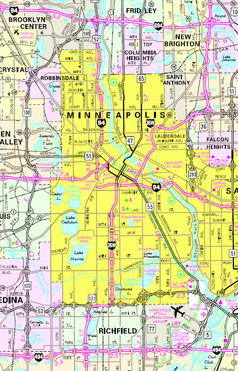
Minnesota State
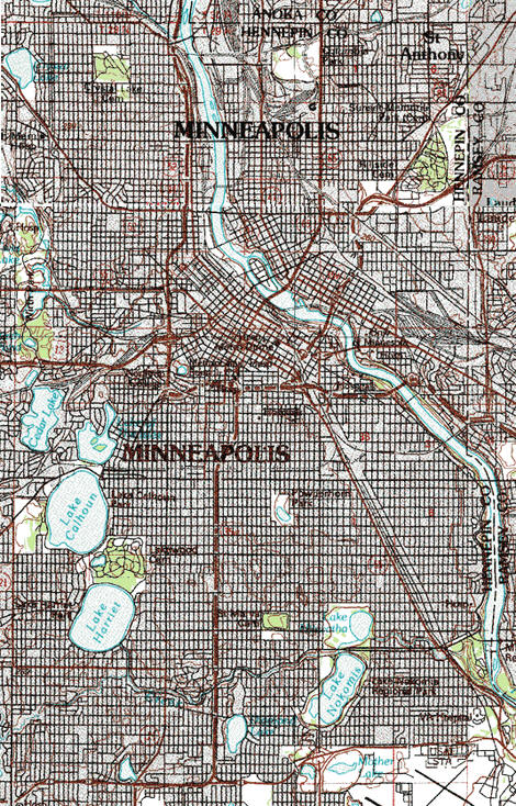
Highway Map of the Minneapolis, Minnesota area
Check Out
The Minnesota
History Shop! Good Goods and
Great Gifts! |
| Lake Name | Size (acres) |
Lake info | Lake Map | Rec Map | Topo Map |
|---|---|---|---|---|---|
|
|
|
|
|
| Local | |
| Metro | |
|
see the Twin Cities Media Guide page for Twin Cities metro area newspapers, radio and TV |
|
|
none within City Limits |
|
|
|
|
|
|
© 2004-2025 LakesnWoods LLC All Rights Reserved |
|
|
|
||