Visit The Minnesota History Shop www.minnesotahistoryshop.com Historic maps Historic books Historic framed art Historic
postcards Clothing with historic
images And much more!!!
Do you have photos, historical accounts or
other items pertaining to the Angle Inlet area? Would you like to
share this historical information with the world?
LakesnWoods.com would like to publish your Angle Inlet photos
(current or historical) or historical accounts on this website.
Original materials can be returned and your privacy will be
respected.
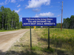
The Northwest Angle, known
simply as the Angle by locals, and coterminous with Angle
Township, is a small part of northern Lake of the Woods County,
Minnesota that is the only part of the United States outside of
Alaska that is north of the 49th parallel. That parallel is the
northern boundary of the 48 contiguous states extending eastward
from the west coast along the northern boundaries of Washington,
Idaho, Montana, North Dakota, and part of Minnesota to the
Northwest Angle.
Further east, U.S.
territory does not extend that far north. Map projections
sometimes create an optical illusion that Maine extends farther
north than that; that illusion does not occur in maps in which
parallels of latitude are straight lines. Like Alaska and Point
Roberts, Washington, the Northwest Angle cannot be reached from
the rest of the U.S. without either going through Canada or
crossing water—specifically, the Lake of the Woods. The
population was 152 at the 2000 census.
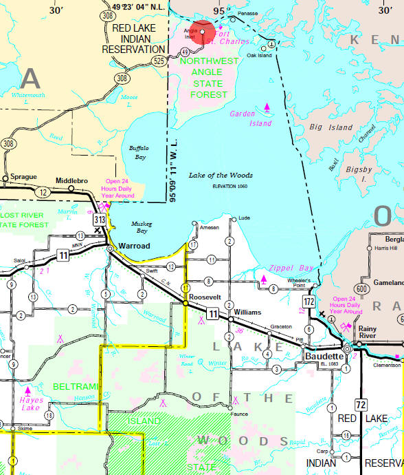
The northwest corner of the Northwest Angle is at 49°23′50.28″N,
95°08′56.7″W.
The Treaty of Paris (1783), concluded between the United States
and Great Britain at the end of the American Revolutionary War,
stated that the boundary between U.S. territory and the British
possessions to the north would run "…through the Lake of the
Woods to the most northwestern most point thereof, and from
thence on a due west course to the river Mississippi…" The
parties did not suspect that the source of the Mississippi, Lake
Itasca, was south of that point. Consequently the Northwest
Angle is the result of 18th-century ignorance of geography. In
the Anglo-American Convention of 1818, the error was corrected
by having the boundary run due south from the northwest point of
the lake to the 49th parallel and then westward along it. When
this north-south line was surveyed, it was found to intersect
other bays of the lake and therefore cut off a portion of U.S.
territory, now known as the Northwest Angle.
The land forming Angle Township is 123.09 square miles (318.81
km²) in area, which actually includes several islands and two
small exclaves which are below (south of) the 49th parallel
north. The exclaves are in the extreme southwest part of the
township, south of the southeast corner of Manitoba, and not far
from the northeast corner of Roseau County. Of the 2000 census
population of 152, there were 118 living on the mainland, and 34
persons on the islands in Lake of the Woods. All of the
populated islands are north of the 49th parallel. The mainland
portion of the township north of the 49th parallel has an area
of 302.075 km² (116.632 sq mi). The total land area of all
islands is 16.325 km² (6.303 sq mi), and the two exclaves total
0.408 km² (0.157 sq mi). The township has the last one-room
public school in the state. The border crossing is unstaffed.
Travelers using the single gravel road into the Angle are
expected to use the telephone provided to contact Canadian or
U.S. Customs and make their declarations. This fact has caused
controversy among many who feel that this unsecured border in a
post-9-11 world is dangerous and could lead to terrorists and
illegal immigrants entering the United States without anyone's
knowledge.
Secession from the United States and annexation by Canada has
been proposed by some area residents on occasion, but little
action has resulted given the proposal's non-urgent nature.
Author Tim O'Brien popularized knowledge of
the location with his bestselling novel, In the Lake of the
Woods, set in the Angle.
Angle Inlet is a census-designated place (CDP) and
unincorporated community in Angle Township, Lake of the Woods County,
Minnesota, United States. Its population was 60 as of the 2010
census. The community is part of the Northwest Angle, the only place
in the contiguous United States north of the 49th parallel; it is the
northernmost census-designated place in the contiguous United States.[4]
The French built Fort Saint Charles nearby in 1732. To travel to Angle
Inlet from other parts of Minnesota by road requires driving through
Manitoba, Canada.
Angle Township is a township in Lake of the Woods
County, Minnesota, United States. The population was 119 at the 2010
census. At 49.22° north latitude, it is the northernmost township in
Minnesota and the contiguous United States. (See extreme points of the
United States and Northwest Angle.) The unincorporated communities of
Oak Island, Angle Inlet and Penasse are located in the township.
According to the United States Census Bureau, the township has a total
area of 596.3 mi2 (1,544.5 km2); 123.1 mi2 (318.8 km2) is land and 473.2
mi2 (1,225.7 km2) (79.63%) water.
The initial establishment of Angle Township being in the United
States was due to a map-maker's error. Benjamin Franklin and British
representatives established the initial U.S. and Canadian borders in the
Treaty of Paris in 1783 from a map that mis-represented the source of
the Mississippi River. In 1997, in order to change what were considered
unequal fishing regulations between the U.S. and Canada, Angle Township
resident Gary Dietzler utilized this cartographical mishap to implement
a mock secession from the United States, going so far as to get a bill
issued by their Congressman Collin Peterson (D) in the U.S. House of
Representatives. The mock secession succeeded in getting fishing
regulations better synchronized across these international (fresh)
waters.
As of the census of 2000,
there were 152 people, 71 households,
and 48 families residing in the
township. The census records all 152 as
White, one also being Hispanic. The
population density was 0.5/km²
(1.2/mi²). There were 272 housing units
at an average density of 0.9/km²
(2.2/mi²).
Of
the 71 households, 10 have children
under the age of 18 living with them, 45
are married couples living together, one
has a female householder with no husband
present, and 22 are non-families.
Seventeen households are made up of
individuals and 4 have someone living
alone who is 65 years of age or older.
The average household size was 2.14 and
the average family size was 2.53.
In Angle Township, 22
people are under the age of 18 (11 girls
and 11 boys), 5 are between 18 and 24,
32 from 25 to 44, 74 from 45 to 64, and
19 are 65 years of age or older. The
median age is 50 years. There are 58
adult women and 72 adult men.
The median income for
a household in the township was $28,500,
and the median income for a family was
$31,250. Males had a median income of
$28,500 versus $21,250 for females. The
per capita income for the township was
$13,932. About 13.3% of families and
12.3% of the population were below the
poverty line. No one under 18 or over 65
lives in poverty.
ANGLE INLET, a post office in T. 168N, R. 34W (Angle
2) since 1936, located on the west bank of the Pine River; the site grew
at a location where travelers left the steamboats from Fort Frances to
board stagecoaches for their overland journey to Winnipeg.
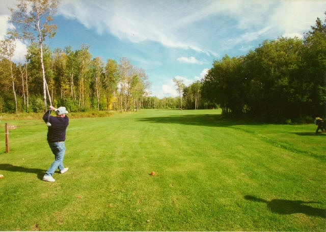
NW Angle Country Club
Angle Inlet, MN 56711
Phone: (218) 223-8001
The most northerly
course in the lower 48 states. Community focal point. Lake of the
Woods borders Holes #4 and #5. Clubhouse for sales and rentals. Tees
and balls available. Golf cart rental and mini-storage located
across the road.
Angle Inn Lodge on Oak Island offers you
the secluded beauty of Minnesota's Northwest Angle.
Completely air conditioned with everything under one roof,
we can accommodate groups or create that secluded "get away"
weekend you've been looking for.
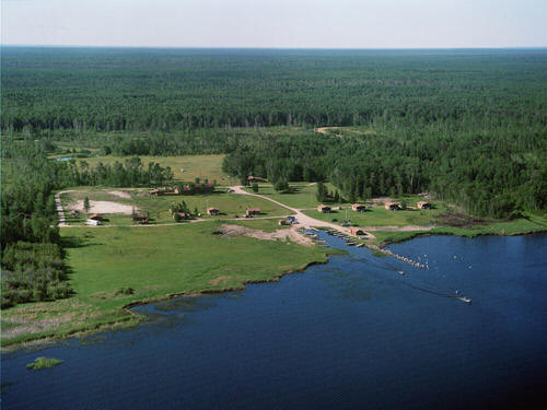
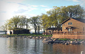
At
Angle Outpost Resort & Conference Center, we feel that the
combination of the great fishing, the stunning beauty and
seclusion of the Northwest Angle region of the lake, our
comfortable cabins, and friendly service is a perfect recipe
for a great time!
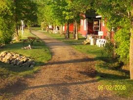
We offer fully modern housekeeping cabins,
which include all linens, towels and blankets. Completely
equipped kitchens include cooking utensils and toasters,
coffee makers, and microwave ovens. Every unit has a fan, an
individual Weber grill and picnic table.
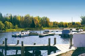
Flag Island Resort is a premier resort located on
Lake of the Woods. Our remote location offers world of endless
water, greenery, and abundant wildlife. Located on one of the
largest fresh water lakes in the world, Flag Island Resort has easy
access to Minnesota and Canadian waters.
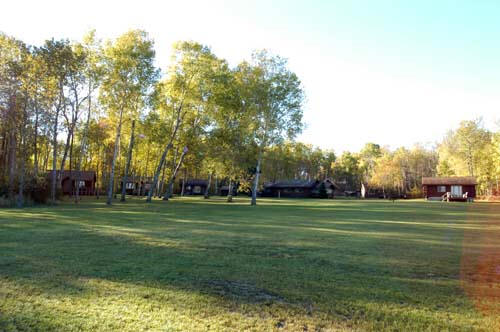
We
boast 6 immaculate cottages, all along Pine Creek. They are
designed for relaxing with deck, satellite TV and a well
equipped kitchen. Our two, three, and four bedroom cabins
have two comfortable twin beds in each bedroom.
Even though the Northwest
Angle has a secluded location, you will find we have very
modern, comfortable, spotlessly clean accommodations. Our
cabins feature Direct TV. We have recently installed
wireless internet to much of the resort for those that wish
to stay connected.
We offer modern housekeeping cabins with
complete kitchen facilities including microwave, coffee
makers, toasters, and cooking utensils. Our rustic lodge has
a fireplace, reading room, satellite TV, small store,
ping-pong and pool table.
Pine Creek
Charter Angle Inlet, MN 56711
Phone: (218) 223-4121
Phone: (218) 754-6181
All cabins are log cabins with modern facilities
that overlook the inlet. Each has a front deck and all electric
kitchens. Fish for walleye, muskies, northerns, and smallmouth bass.
Fish cleaning and packaging available.
We
boast 6 immaculate cottages, all along Pine Creek. They are
designed for relaxing with deck, satellite TV and a well
equipped kitchen. Our two, three, and four bedroom cabins
have two comfortable twin beds in each bedroom.
Young's Bay Resort
7600 Young's Bay Drive NW
Angle Inlet, MN 56711
Phone: (218) 223-8031
Almost live webcam from Flag
Island Minnesota
Courtesy
Yahooey.com
Angle Inn Lodge on Oak Island offers you
the secluded beauty of Minnesota's Northwest Angle.
Completely air conditioned with everything under one roof,
we can accommodate groups or create that secluded "get away"
weekend you've been looking for.
At
Angle Outpost Resort & Conference Center, we feel that the
combination of the great fishing, the stunning beauty and
seclusion of the Northwest Angle region of the lake, our
comfortable cabins, and friendly service is a perfect recipe
for a great time!
Blackbird Island
PO Box 4 Angle Inlet, MN 56711
Phone: (218) 223-4719
Flag Island Resort is a premier resort located on
Lake of the Woods. Our remote location offers world of endless
water, greenery, and abundant wildlife. Located on one of the
largest fresh water lakes in the world, Flag Island Resort has easy
access to Minnesota and Canadian waters.
Flag Island Weather Station
2423 Flag Island
Angle Inlet, MN 56711
Phone: (218) 223-4023
Island Passenger Service
2379 Flag Island
Angle Inlet, MN 56711
Phone: (218) 223-5015
J & M General Store
9385 Golf Course Drive NW
PO Box 112
Angle Inlet, MN 56711
Phone: (218) 223-4381
We
boast 6 immaculate cottages, all along Pine Creek. They are
designed for relaxing with deck, satellite TV and a well
equipped kitchen. Our two, three, and four bedroom cabins
have two comfortable twin beds in each bedroom.
Laketrails program is designed with the
teenage camper in mind. While there is plenty of adventure as
well as physical challenge, there is also a more relaxed
atmosphere than you will find at many camps. The heart of our
program is a five to six day wilderness canoe trip geared to the
experience level of the individual group.
Northwest Angle Country Club
Angle Inlet, MN 56711
Phone: (218) 223-8001
The most northerly
course in the lower 48 states. Community focal point. Lake of
the Woods borders Holes #4 and #5. Clubhouse for sales and
rentals. Tees and balls available. Golf cart rental and
mini-storage located across the road.
Even though the Northwest
Angle has a secluded location, you will find we have very
modern, comfortable, spotlessly clean accommodations. Our
cabins feature Direct TV. We have recently installed
wireless internet to much of the resort for those that wish
to stay connected.
Northwest Angle Services, Inc.
PO Box 12
Angle Inlet, MN 56711
Phone: (218) 223-4251
We offer modern housekeeping cabins with
complete kitchen facilities including microwave, coffee
makers, toasters, and cooking utensils. Our rustic lodge has
a fireplace, reading room, satellite TV, small store,
ping-pong and pool table.
Paw Path Art Studio
Angle Inlet, MN 56711
Phone: (218) 223-4785
Pine Creek
Charter Angle Inlet, MN 56711
Phone: (218) 223-4121
Phone: (218) 754-6181
All cabins are log cabins with modern facilities
that overlook the inlet. Each has a front deck and all electric
kitchens. Fish for walleye, muskies, northerns, and smallmouth bass.
Fish cleaning and packaging available.
Skjeberg Lutheran Church Angle Inlet, MN 56711
Phone: (218) 455-6198
Non-denominational worship service
10:30 AM Sundays